

In the heart of the entertainment industry, facilitating on-location filming across Greater Los Angeles requires a delicate balance between community needs and a thriving local economy. As the official, not-for-profit film office for the region, FilmLA simplifies the permitting process for filmmakers. However, as location permits grew increasingly complex, tracking overlapping events both spatially and temporally called for an innovative geospatial solution.
The Challenge: Moving Past ‘Encyclopedic Knowledge’ and Duplicate Data
Historically, FilmLA’s workflow relied heavily on the manual expertise of individuals with encyclopedic knowledge of Los Angeles and its bustling event schedule. As permit volumes expanded, this approach became entirely unsustainable.
The core operational challenge centered around managing overlapping events with a recurring, interval-based component—such as Dodgers home games. FilmLA’s early attempts to tackle this involved:
- Creating entirely separate geospatial features for each individual event recurrence.
- Generating massive amounts of duplicate data.
- Creating a problematic editing workflow where updates had to be manually applied across multiple features rather than a single record.
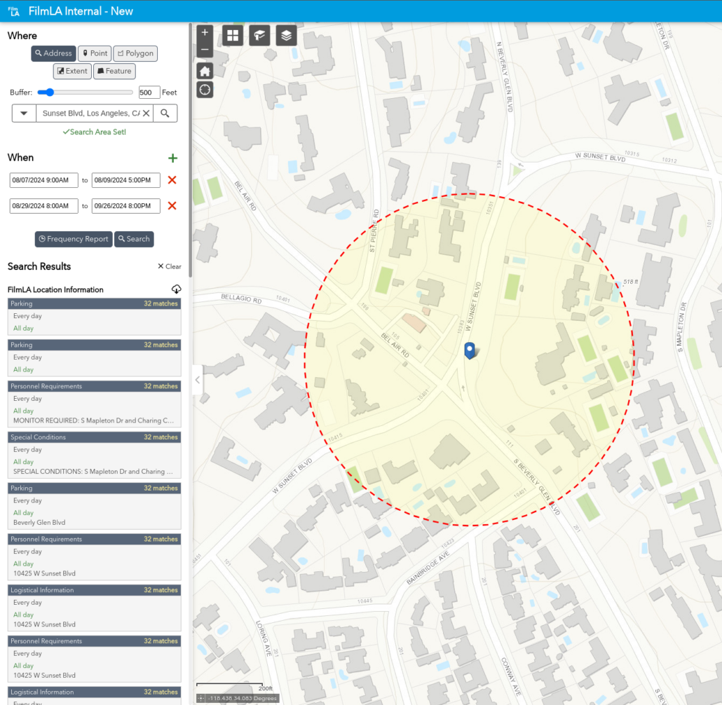
Permitting agents needed a way to quickly analyze spatial and temporal conflicts to avoid community disruptions and prevent back-to-back oversaturation in high-demand areas.
The Solution: Interval-Aware Geospatial Architecture
To modernize this workflow, FilmLA recognized the need for a GIS-based solution leveraging ArcGIS Enterprise. They partnered with GEO Jobe, an Esri Platinum Tier Partner specializing in custom Web GIS and Desktop GIS solutions.
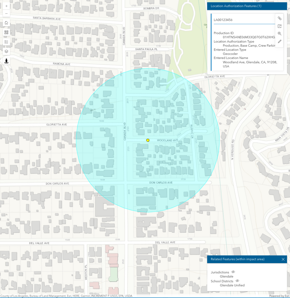
Together, they engineered a custom data model that introduced interval-aware attributes directly to the GIS layers. This architectural shift delivered critical capabilities:
- No More Data Duplication: Detailed scheduling data can now be attached directly to spatial features without duplicating geometries.
- Dynamic Adjustments: A user-friendly feature-editing interface lets permitting agents easily set up and dynamically adjust schedules to maintain up-to-date data.
- Instant Conflict Identification: A custom search widget empowers agents to instantly identify potential spatiotemporal conflicts based on input criteria, allowing them to proactively adjust film permit requests.
“Our collaboration with GEO Jobe brought results beyond speed and efficiency—by incorporating time of use as a geospatial data point, the system eliminates false positives that previously required manual review.” — Bruce Ekstein, Director of IT, FilmLA
Business Outcomes: Data-Driven Film Permitting
By transitioning to interval-aware geospatial data and deploying the custom search tool, FilmLA completely transformed its operational capabilities. Permitting agents are now empowered to:
- Instantly assess potential conflicts within a requested time and location range.
- Efficiently manage an ever-growing repository of complex spatiotemporal data.
- Leverage readily available data to suggest minor application adjustments, turning what would have been a permit denial into an approval.
“The implementation of interval-aware geospatial data within FilmLA’s ArcGIS Enterprise environment, coupled with the custom search widget developed by our team, has demonstrably enhanced their operational efficiency. This solution empowers FilmLA’s permitting agents to make informed decisions with unparalleled confidence in their data…” – Eric Goforth, Chief Technology Officer, GEO Jobe
The Future of Spatial Intelligence in Hollywood
Through this partnership, FilmLA has set a new standard for the film industry by embracing spatial intelligence to drive smarter, highly efficient decisions. Supported by GEO Jobe’s expertise, Hollywood’s permitting ecosystem is now more intuitive, scalable, and future-proof. Moving forward, the two organizations continue to collaborate closely, positioning FilmLA to explore even deeper innovative applications of GIS technology.
To learn more about our offerings and solutions, and how we can improve your workflows, please reach out at connect@geo-jobe.com, or visit www.geo-jobe.com.
If you found this interesting, check out these other case studies:
- Partners Helping Partners: How GEO Jobe Helped OHM Advisors Unlock the Power of ArcGIS Enterprise
- Avolve, GEO Jobe Announce Integrated Electronic Plan Review Software with Esri GIS Technology
- Vanderbilt University: Landscape Planning with UAV Tech
- Esri StoryMaps Take GPT Airport to New Heights
About Our Company
GEO Jobe is a leading GIS software and geospatial solutions provider, serving more than 12,000 organizations globally. The company is most known for developing some of the industry’s most popular applications, including Admin Tools for ArcGIS, Backup My Org, Clean My Org, Manage My Attachments, and Symphony for ArcGIS.
GEO Jobe offers U.S.-based 24/7 Support for organizations using Esri’s ArcGIS© System. GEO Jobe also offers professional services focused on Esri’s ArcGIS System, including custom software development, enterprise solution implementation, data science and UAV data collection.
Founded in 1999, GEO Jobe has been in operation for more than 25 years and an Esri business partner since 2002, and is currently a Platinum Partner.
