Sharing data can be a touchy subject. In general, it seems that people and institutions do not like their research and findings being freely accessible to the public. If you have worked on any project requiring data you could not collect on your own, you have more than likely jumped onto the World Wide Web to find an article or relevant dataset(s). This search leads you to a website that seems to have exactly what you are looking for, and the sense of victory is overwhelming!
But wait a second.
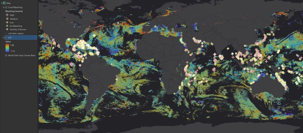
You eagerly click the link to access the data you plan to use to visualize the relationship between sea surface temperature (SST) and global coral bleaching, and are hit with a price tag. The cost of reputable data tends to be a barrier for students, researchers, small businesses, and generally curious, independent minds, ultimately preventing further learning and problem solving.
Open data is an invaluable tool, and many governments and organizations recognize that. After some searching, I found the data needed to create a map showing SST and coral health. The SST data came from NOAA, which has an excellent data portal with several satellite datasets available for download. For coral health data, I ended up on the ReefBase website. ReefBase is an organization funded by the International Coral Reef Action Network (ICRAN) and the United Nations Foundation (UNF). They understand the harm that can be caused by inaccessible data, and consequently work to compile reef data from a variety of trustworthy sources into a centralized location for anyone to download and view.
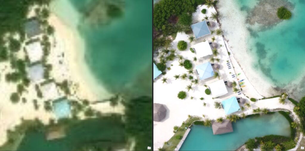
Though I am slightly biased from having worked with this organization, a favorite open data source of mine is Citizen Science GIS, including their Open Reef imagery collection. Open Reef was started with the intention of offering high quality, open source aerial imagery of every island in Belize in order to support research, policy, and education. By searching “openreef” when adding layers to a web map in ArcGIS Online (or through Portal in ArcGIS Pro), you will find several high resolution orthomosaics and digitized features. Here are some examples of the standard satellite basemap (left) versus the drone imagery (right):

In addition to their public imagery, CSGIS has an ArcGIS Hub site with the data they have collected in Hopkins, Belize over the course of the past four summers. This includes drainage features, roads, structures, tourism locations, marine debris, and community-defined flooding hotspots. All of the data are available for download or to use in web mapping applications. ArcGIS Hub is a fantastic application for distributing data, gathering community input, or simply sharing maps with a broader audience. GEO Jobe was recently awarded the ArcGIS Hub Specialty Designation by Esri, so we are ready and fully equipped to help your organization get started with ArcGIS Hub!
If you are looking for data a little closer to home than Belize (depending on where you are, of course!), many city and state governments offer open source GIS products. New York State, for example, has a large selection of publicly available geospatial data and web services. On the Federal level, the USGS’s EarthExplorer has an overwhelming amount of satellite data, and while accessing it requires creating a free account, signing up is a quick and painless process. Additionally, the US Census Bureau has just about any dataset you could imagine on their mapping page. Although finding free, reputable data may seem like a daunting task at times, there are certainly sources available to support your GIS projects!