

For nationwide maintenance, repair, and operations (MRO) distributors like Hi-Line, operating a fleet of mobile, fully stocked service vehicles hinges on accurate geographic intelligence. Every marketing effort and operational strategy relies heavily on spatial data to reach the right regions efficiently. However, as Hi-Line expanded its spatial data capabilities, the team hit a common hurdle in enterprise GIS: maintaining workflow consistency and repeatability across defined geographic boundaries.
Generating reliable spatial outputs across predefined regions was proving difficult. Existing manual workflows took over two hours per run, introducing human error and variable results due to a lack of standardized, reusable spatial logic. Hi-Line needed a practical, scalable method to optimize its Esri stack, eliminate manual overhead, and ensure consistent outputs across multiple runs without adding unnecessary architectural complexity.
To solve this challenge, Hi-Line partnered with GEO Jobe to design a custom, streamlined solution focused on automation, standardization, and long-term maintainability.

“The workflow that Hi-Line needed automated initially seemed simple but turned out to be especially challenging. However, by working closely with Hi-Line, we developed creative solutions that combined custom code with multiple out-of-the-box solutions that Esri provides. We were able to tackle the challenge in a way that exceeded Hi-Line’s expectations.”
-Heather Nicholson, Solutions Engineer at GEO Jobe.
The technical architecture was designed around core Esri tools to ensure seamless integration and ease of use. GEO Jobe utilized ArcGIS Pro for initial spatial data preparation, validation, and workflow development. Standardized geoprocessing workflows were established to enforce repeatable spatial logic across defined geographic extents. For deployment and collaboration, ArcGIS Online hosted, visualized, and shared the spatial outputs using hosted feature layers that ensured broad access to authoritative spatial data.
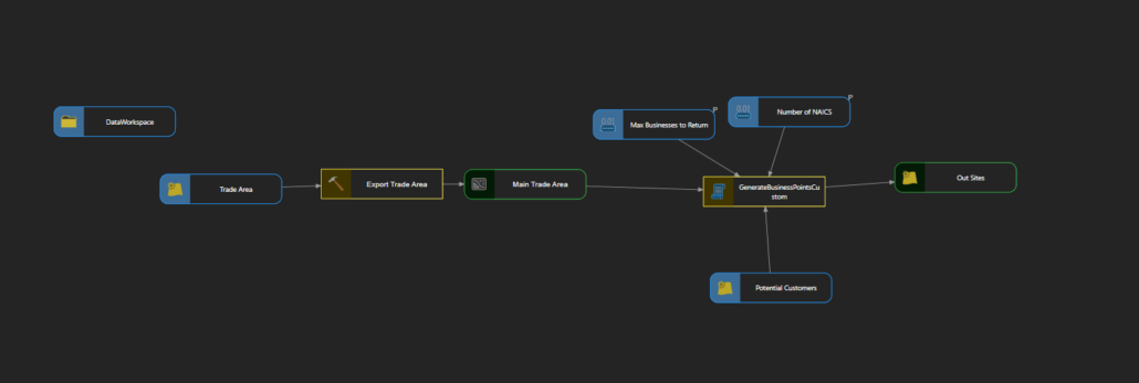
The outcome transformed Hi-Line’s spatial processing operations. By incorporating automated spatial logic alongside built-in quality control and data validation steps, GEO Jobe reduced the processing time of a manual workflow from over two hours down to less than 10 minutes. Final spatial outputs are now delivered in a consistent, standardized format that can easily be reused across marketing and operational workflows. The entire lightweight design minimizes dependencies, giving Hi-Line room to scale as their spatial requirements grow over time.

“GEO Jobe provided a clear, effective solution that addressed exactly what we needed. The project stayed on schedule and within budget, and the final result fits seamlessly into our workflow.”
-Jason Strange, VP Digital Marketing at Hi-Line.
By pairing out-of-the-box Esri technology with tailored spatial logic, Hi-Line transitioned a slow, variable manual task into a highly reliable, automated GIS asset. Teams now generate spatial outputs with speed, precision, and complete data confidence.
About Hi-Line
Hi-Line Inc. is a nationwide distributor and mobile industrial hardware store founded in 1959. It delivers maintenance, repair, and operations (MRO) supplies directly to commercial clients using fully-stocked mobile trucks managed by trained territory managers.
To learn more, visit https://hi-line.com/

About Our Company
GEO Jobe is a leading GIS software and geospatial solutions provider, serving more than 12,000 organizations globally. The company is most known for developing some of the industry’s most popular applications, including Admin Tools for ArcGIS, Backup My Org, Clean My Org, Manage My Attachments, and Symphony for ArcGIS.
GEO Jobe offers U.S.-based 24/7 Support for organizations using Esri’s ArcGIS© System. GEO Jobe also offers professional services focused on Esri’s ArcGIS System, including custom software development, enterprise solution implementation, data science and UAV data collection.
Founded in 1999, GEO Jobe has been in operation for more than 25 years and an Esri business partner since 2002, and is currently a Platinum Partner.