
“Quality data is as essential to Machine Learning as practice and quality instruments are to an orchestra. Be the conductor.”
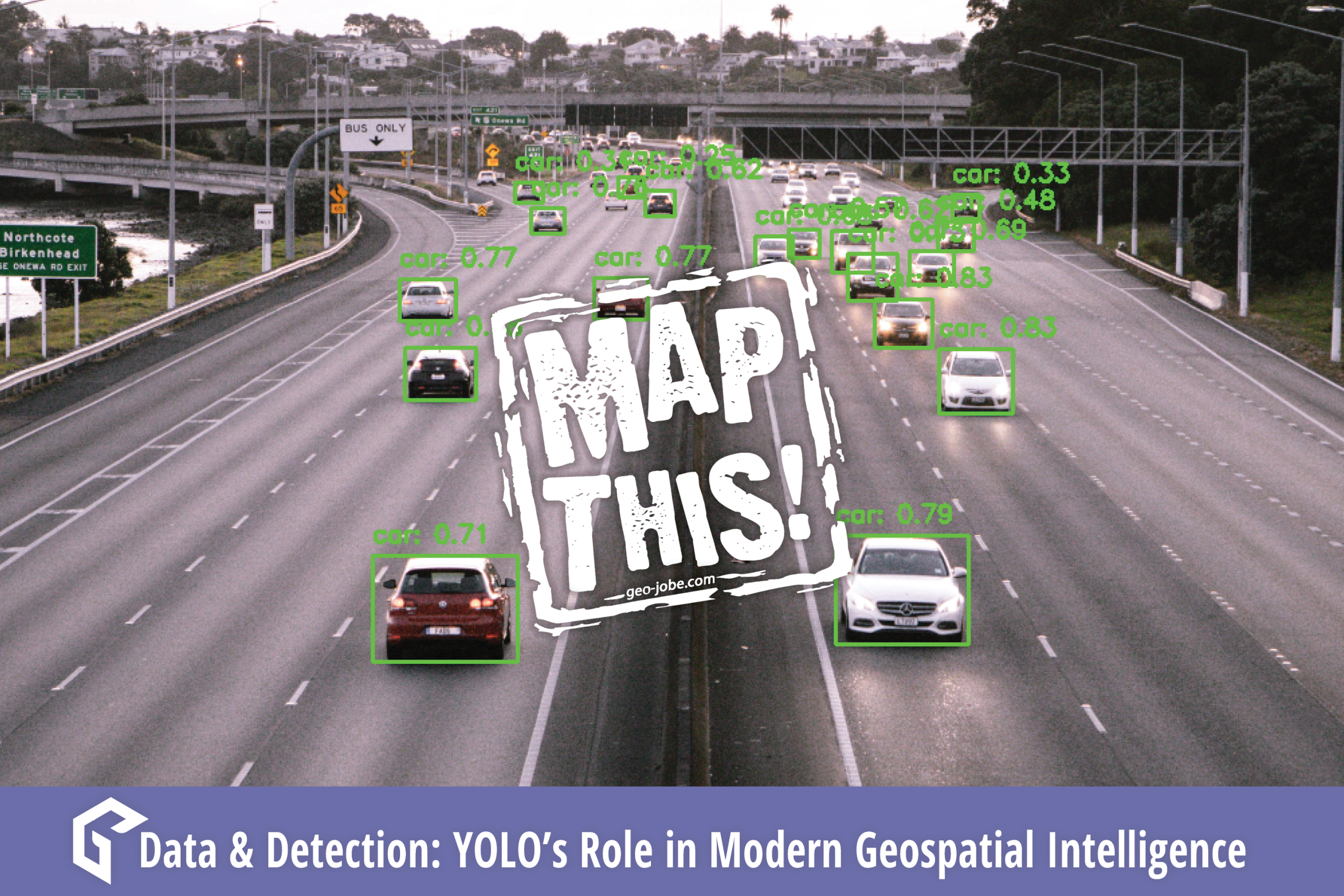
In the ever-evolving world of machine learning, YOLO (You Only Look Once) stands out as a game-changer for real-time object detection.
Unlike other models that sacrifice speed for precision, YOLO’s single-pass processing delivers lightning-fast inference, making it the go-to choice for applications like live-stream analysis, drone surveillance, and rapid-response threat detection. With Ultralytics’ latest YOLOv11 models and customizable training options, GIS professionals can harness its power for tasks ranging from aerial surveying to wildlife tracking and disaster response.
Dive into the world of YOLO and discover how this cutting-edge framework is reshaping geospatial intelligence.
Background
YOLO, or You Only Look Once, is a machine learning framework and family of ML/DL models focused on real-time object detection and inference. One key distinction that YOLO has is single-pass processing over images, provided an adequately pretrained model, results in significantly better performance. Each machine learning model or framework has unique strengths and specializations.
Faster R-CNN, which replaces Fast R-CNN’s selective search algorithm with a Region Proposal Network, excels at object detection with impeccable accuracy, but at the trade-off of speed. Vision Transformers (a personal favorite) offer fantastic image classification performance with feature learning and global context awareness, making them ideal for analyzing and associating relationships between all parts of an image simultaneously, as opposed to localization of features, such as an iteration over a motorcycle identifying a wheel instead of relating the wheel as part of the motorcycle.
The speed advantage of YOLO models is what makes them stand out, making them ideal for applications like live-stream inference, threat analysis and rapid response, as well as drone-based capture with quick assessment.
Custom Training
Ultralytics, the developer of the YOLO model and framework, provides all of their models, documentation, and testable datasets on their website: docs.ultralytics.com. For a specific use-case, such as drone-image captures or live streams, the user would first choose a YOLOv11 model for the specific task in mind, from Detection, Instance Segmentation, Pose/Keypoints, Oriented Detection (rotated bounding boxes), or Classification, as well as a model size from Nano, Small, Medium, Large, and Extra Large, denoted n, s, m, l, x.
Increasing the model size increases the complexity, model parameters, and accuracy, but can reduce speed. For example, real-time imagery for security might use a medium Pose YOLOv11 model, YOLO11m-pose, to balance accuracy but maintain critical speeds to handle threat analysis, whereas a drone surveying a forest for possible injured or missing persons might run nano Detection or Oriented Detection (yolo11n.pt/yolo11n-obb.pt) in order to identify people while not draining the drone’s battery for long flights, sending back the imagery and location of capture in discovery.
This example notebook demonstrates how one would train a model to suit their needs. Ultralytics provides manifold datasets which can help, such as the VisDrone dataset which contains ground truth data for drone-based image and video analysis. This training has a large initial training time, at the end of which the pretrained model would be migrated to its living location, such as onto a drone, or receiving endpoint of imagery/stream data, and run from there.
# Necessary installations
%pip install ultralytics opencv-python

# Used to access some COCO images for testing
%pip install fiftyone pycocotools
Python Training Example
from ultralytics import YOLO

# Load a model
model = YOLO("yolo11n.pt")  # load a pretrained model (recommended for training)

# Train the model
results = model.train(data="VisDrone.yaml", epochs=100, imgsz=640)
CLI Training Example
# Start training from a pretrained *.pt model
yolo detect train data=VisDrone.yaml model=yolo11n.pt epochs=100 imgsz=640
Utilizing, Visualizing, Testing
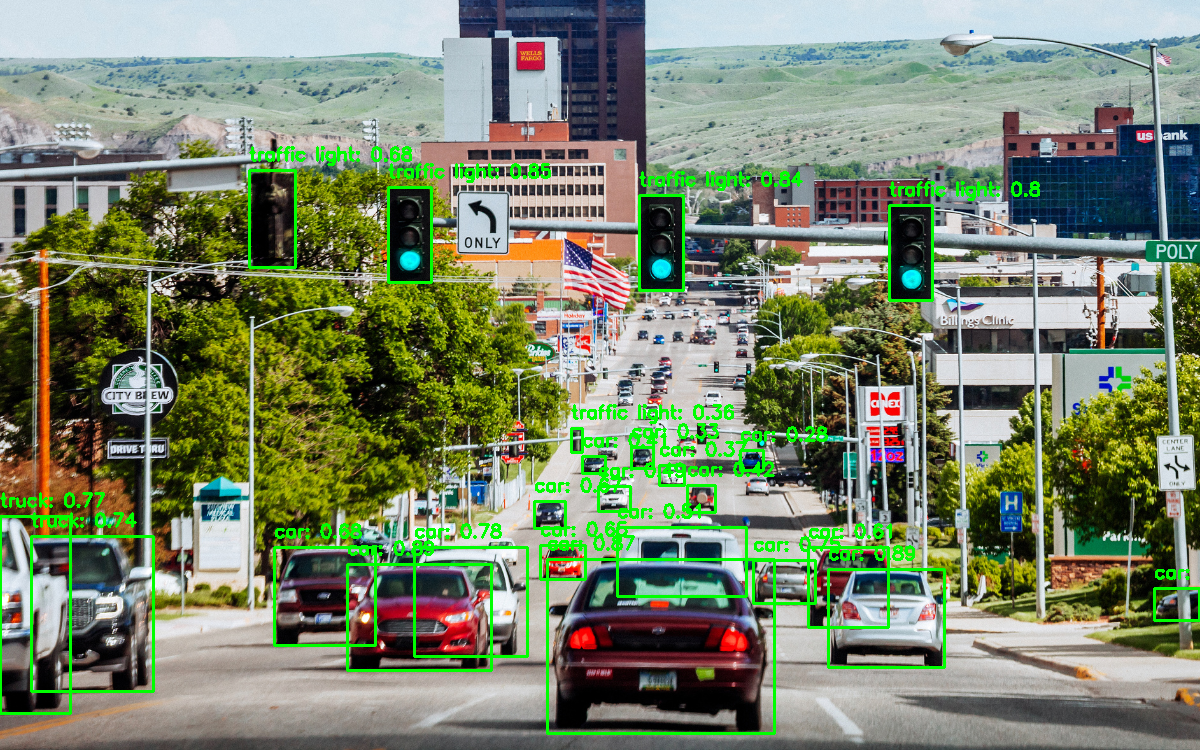
The training function will generate a folder under “runs” which will contain each trained model. The folder also contains confusion matrix data, training results, the F1 Curve, arguments, weights, validation, and more. Below is a small code demonstration of how to borrow a subset of the COCO (Common Objects in Context) dataset from FiftyOne to use for testing and validation.
By default, the VisDrone dataset contains 10 classes : pedestrian, people, bicycle, car, van, truck, tricycle, awning-tricycle, bus, motor. This dataset is specifically-focused in its classes, but robust in respective depth. COCO, contains over 70 classes with over 330,000 images, developed in collaboration with CVDF, Microsoft, Facebook, and Mighty AI. Upon training, several files are generated, such as the F1 Confidence curve, which evaluates the models performance by plotting the F1-score (harmonic mean of the precision and recall).
For demonstration purposes, the below code will utilize a pretrained Medium Detection model (Denoted yolo11m.pt in the code, however if you would prefer to use the VisDrone trained nano model from above, or a model trained on your own personal data, use the commented out model definition on line 18 instead.
import os, random, cv2
import matplotlib.pyplot as plt
from ultralytics import YOLO
import fiftyone as fo

dataset = fo.zoo.load_zoo_dataset(
    "coco-2017",
    split="validation",
    label_types=["detections", "segmentations"],
    classes=["person", "car"],
    max_samples=50,
)

# Utilize a pretrained model from Ultralytics, for simplicity
model = YOLO("yolo11m.pt")

# Use the below line if utilizing a trained model
# model = YOLO("runs/detect/train1/weights/best.pt")

quickstart_path = os.path.expanduser("~/fiftyone/quickstart/data")

image_files = [f for f in os.listdir(quickstart_path) if f.endswith((".jpg", ".png", ".jpeg"))]
random_images = random.sample(image_files, 5)
plt.figure(figsize=(15, 10))

for i, img_file in enumerate(random_images):
    img_path = os.path.join(quickstart_path, img_file)

    img = cv2.imread(img_path)
    img = cv2.cvtColor(img, cv2.COLOR_BGR2RGB)

    # YOLO Model Inference
    results = model(img_path)

    # Draw bounding boxes with Class Index, Confidence
    for result in results:
        for box in result.boxes:
            class_id = int(box.cls.item())
            confidence = round(box.conf.item(), 2)
            bbox = [int(x) for x in box.xyxy[0]]

            cv2.rectangle(img, (bbox[0], bbox[1]), (bbox[2], bbox[3]), (0, 255, 0), 2)

            # Label
            label = f"{model.names[class_id]}: {confidence}"
            cv2.putText(img, label, (bbox[0], bbox[1] - 10), cv2.FONT_HERSHEY_SIMPLEX,
                        0.6, (0, 255, 0), 2)

    # Display
    plt.subplot(2, 3, i + 1)
    plt.imshow(img)
    plt.axis("off")
    plt.title(f"Image {i+1}")

plt.tight_layout()
plt.show()
Applications in GIS
In the realm of GIS, YOLO’s lightweight and speedy framework is applicable for various UAV and high-resolution satellite image captures. Object Detection in aerial surveying being the most prevalent of these, by putting a trained, lightweight model on a drone with mapped flight pattern to detect any specific focus item such as trees, vehicles, pedestrians, buildings, utilities, and more.
Similarly, wildlife tracking via drone could be performed, or region-wide counting of species. Land use classification could be performed, using the computer vision to identify urban, agricultural, and forested regions, or expanded to include flooded vegetation, farm crop, or snowed/iced areas. Satellite imagery could be utilized for rapid disaster reporting and response.
Leveraging YOLO for Your Organization
As geospatial technology continues to evolve, the integration of AI-powered object detection models like YOLO is unlocking new possibilities for efficiency, accuracy, and real-time decision-making. Whether you’re looking to enhance UAV-based surveying, streamline wildlife tracking, or improve disaster response, YOLO’s speed and adaptability make it an invaluable tool.
At GEO Jobe, our Data Science team specializes in leveraging cutting-edge machine learning models, including YOLO and others, to help you achieve your geospatial goals. Contact us at connect@geo-jobe.com to learn more about how we can tailor solutions like these to fit your needs.
Let’s harness the power of AI-driven GIS together!
Sources:
VisDrone dataset
P. Zhu, L. Wen, D. Du, X. Bian, H. Fan, Q. Hu, and H. Ling, “Detection and Tracking Meet Drones Challenge,” IEEE Transactions on Pattern Analysis and Machine Intelligence, vol. PP, no. 99, pp. 1–1, 2021, doi: 10.1109/TPAMI.2021.3119563.
Ultralytics YOLOv11
Ultralytics, “Ultralytics YOLOv11” GitHub, 2025. [Online]. Available: https://github.com/ultralytics/ultralytics
Faster R-CNN
S. Ren, K. He, R. Girshick, and J. Sun, “Faster R-CNN: Towards real-time object detection with region proposal networks,” Advances in Neural Information Processing Systems (NeurIPS), 2015. [Online]. Available: https://arxiv.org/abs/1506.01497
FiftyOne
FiftyOne, “FiftyOne: The Open-Source Tool for Computer Vision,” 2025. [Online]. Available: https://www.voxel51.com/fiftyone. [Accessed: 01-Apr-2025].
Interested in more from GEO Jobe? Explore these other MapThis! articles:
- UAV Mapping: Maximizing Accuracy with Ground Control Points
- 25 Years of GEO Jobe: Mapping a Legacy of Innovation & Community
- WATCH: Sharing Your ArcGIS Services Easier, Smarter, & More Securely
- Powering Geoanalytics with Databricks and Spark Integration
About Our Company
GEO Jobe is a leading GIS software and geospatial solutions provider, serving over 10,000 organizations globally. GEO Jobe is best known for developing the most popular applications in the ArcGIS Marketplace, including Admin Tools for ArcGIS, Backup My Org, Clean My Org and Scheduler for ArcGIS.
GEO Jobe offers U.S.-based 24/7 Support solutions for organizations using Esri’s ArcGIS© System. GEO Jobe also offers professional services focused on Esri’s ArcGIS© System, including custom software development, enterprise solution implementation, data science and UAV data collection.
Founded in 1999, GEO Jobe is in its 25th year of operation, has been an Esri business partner since 2002 and is currently a Platinum Partner.
