To date, 2020 has been unlike any year over the past century. The COVID-19 pandemic has thrown us a giant curveball, disrupting every aspect of our lives, including how we work, play, and go to school. Home-based activities have become the norm as communities, cities, states, and even entire countries have had to adapt to “a new normal”. With this new normal, there has been a massive move towards online education, distance learning, and professional development delivered via the Internet.

With this new normal, there has been a stronger interest in E-learning from the GIS and Geotech industry. For students and young, up-and-coming GIS professionals, the school year and normal educational workflow has been interrupted. This has meant a rapid shift to web-based content delivery for most schools and higher learning institutions – luckily, for many, there has always been a strong E-learning presence and a wide selection of curriculum in the geospatial industry.
Additionally, there has always been a relatively robust selection of “non-credit” sources, professional development, and E-learning – for example, offerings via the likes of Udemy, Esri online learning resources, free MOOCs, Codecademy, and many others. However, with the pandemic and the subsequent shutting down of the economy, there are likely tens of thousands of GIS industry people who have lost their jobs, been furloughed, are out of school, or otherwise displaced from the workforce. For these professionals, this has been an opportunity to use the time at home to acquire new skills and advance their opportunities by participating in distance learning and online education.
To say that there are many opportunities for E-learning and education for the GIS industry would be an understatement! Education comes in many forms and a wide range of delivery options. Below, we explore a number of opportunities and options that exist, including:
- Webinars
- MOOCs
- Videos – UC & Devsummit videos
- Developer resources
- Other education & free training
Webinars
Webinars have been a staple in the GIS industry for many years. Companies, government agencies, NGOs, and others continue to produce and deliver fine webinar content on almost any topic imaginable, and, best of all, these web-based offerings are typically archived where they can be accessed at any time for future reference.
Esri has perfected the art of webinar delivery, producing seminars to educate and inform on all of their products and more. These webinars are an ideal way to learn directly from the Esri team leads as they share tips on how to master the ArcGIS platform and inform users of what to expect from products as they evolve. Be sure to consult the Esri webinars as well as those shared by Esri Canada. Developers and those who need to stay up to speed with the ArcGIS APIs, Python, and JavaScript will want to browse the offerings from the GeoDev webinar series. Finally, Esri has hundreds of business partners. Therefore, there are thousands of GIS professionals who are working as partners. For these folks, there are technical enablement webinars made available specifically for you from Esri.
Speaking of Esri partners, many of the fine Esri partners and solution providers frequently deliver webinars to the public. These are a great source of information and inspiration that educate you on how others are building on the ArcGIS platform and leveraging the Esri ecosystem for their business. A few webinars from partners and others to check out include:
- Geocortex webinars
- Webinars from Safe Software (FME)
- SimActive training (image processing)
- USGIF events and webinars
- Carahsoft events
MOOCs
Esri has done a fine job introducing the community to the “MOOC” – A MOOC refers to a Massive Open Online Course. So, what exactly is a MOOC? According to Esri, a MOOC:
- Covers a single theme or topic
- Allow students to study whenever they have time, at their own pace
- Encourage students to learn from one another
- Include videos, exercises, discussions, quizzes, polls and surveys
- Provide free access to the latest Esri software for the duration of the course
- Involve four to six weeks of instruction, with a minimum of two-three hours per week of study
- Require registration but are free to take
- Have a firm start and end dates
- Provide certificates to students who complete the course material
- Introduce students to subject matter experts from across Esri and its community
Of particular interest, the popular Cartography. MOOC from Esri has been the most popular offering, educating tens of thousands of professionals on cartography and how to create amazing, beautiful maps. If you missed out this time don’t worry, the MOOC will likely repeat again in the near future. Also noteworthy, another offering titled “Migrating from ArcMap to ArcGIS Pro” – This course is designed to help experienced ArcMap users transition smoothly to ArcGIS Pro. Learn more about ESRI MOOCs here.
Videos
For anyone who is working from home, and particularly if you are quarantined, a feeling of isolation is going to kick in eventually. Sadly, this is one rough aspect that most people who work from home-based offices go through at some time. This means that some form of interaction is craved, or perhaps, just that feeling of hanging out with others. To assist with this, there is a massive amount of online videos. In particular, sessions that have been recorded from conferences and other events. Of particular, these video libraries are a must to consider and bookmark:
E360 Videos from Esri is a wonderful collection of interviews, presentations, and conference materials from Esri. The channel is very professional and all the content is high quality – created, and produced by Esri’s AV professionals. There is a vast selection of content here, ranging from “What is GIS Day?”, to Jack Dangermond sharing his vision for a sustainable future.
Esri Canada Videos – The Canadian arm of Esri has an excellent video archive on YouTube where users will find a wealth of technical videos that share informative and educational content on such topics as ArcGIS Enterprise, Survey123, ArcGIS Dashboards and more. Content is sorted according to technical videos and by industry.
Esri’s main account on YouTube has all their video archives made available (note, much of this is also on E360). The Community tab on the channel is particularly useful!
Esri Events Channel – This is likely our favorite Esri-related video channel, and is where all the archived sessions from Esri events, including the annual ESRI UC and DevSummit are found – be careful visiting this one because you’ll likely get pulled in for hours of viewing!
GEO Jobe Videos – Like most technology companies and solution providers, we also maintain a video archive here at GEO Jobe. Our library has a number of videos from over the years, including recordings from ESRI UC and DevSummit conferences, as well as several webinars that we hosted. We also share a number of how-to and tutorial videos for users of our popular Admin Tools for ArcGIS Online, for example, how to use the Copy Symbology Function. For those interested in UAV/drone technology, we also have a number of recordings from some of the interesting missions that we’ve flown around the country.
ArcGIS Developer Resources and Training
For the GIS / Geo developer, or would-be developer, there are a number of fine, educational resources to help you hone your technical skills. These online offerings are ideal for those who find themselves confined to a work-from-home situation or for students looking to get a leg up on the job search competition.The ArcGIS DevLabs are your go-to resource for learning how to build maps and apps using ArcGIS APIs, SDKs, and other tools. Created by developers for developers, the Labs are where you’ll find tons of lessons and tutorials that explain exactly how to accomplish something with your tools of choice. The lessons are as simple as describing how to create a web map and grow in complexity, from teaching you how to style a vector base map to how to determine optimal routes and directions from your offline app! The Labs are a must-use for any ArcGIS developer! Note, for young developers, students, and others that are new to the industry, our own Courtney Kirkham is a frequent author of developer tips and other articles of interest on building a career as a GeoDev! See Courtney’s archive.
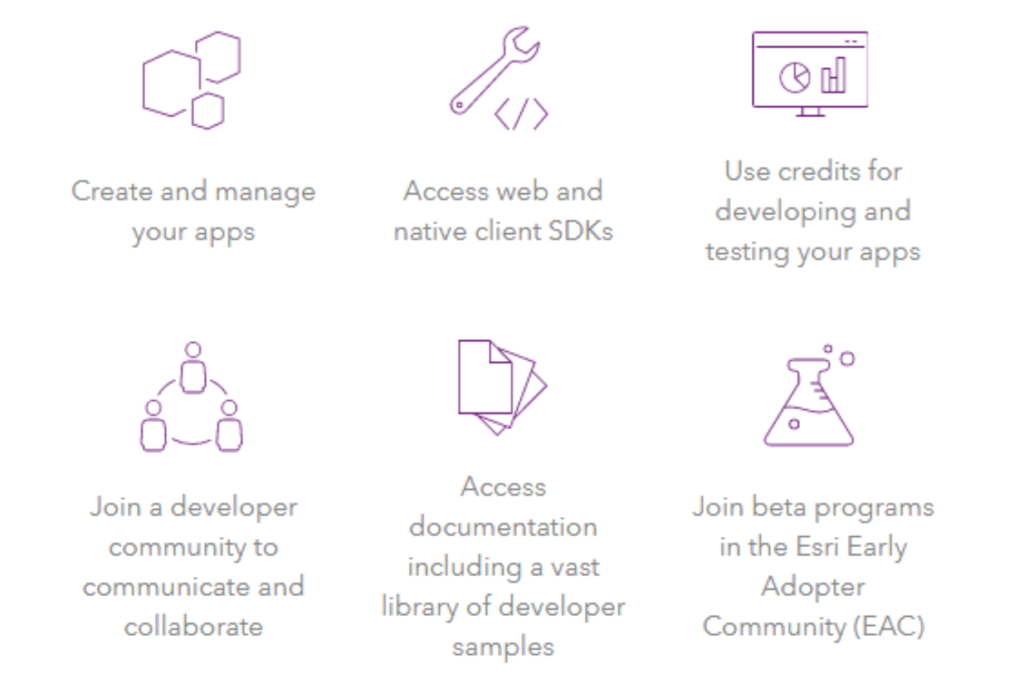
If budget is a concern for you, don’t worry because Esri has created the free, ArcGIS developer account. This is the perfect solution for anyone who finds themselves out of work, between gigs, or is just new to this whole “ArcGIS thing” and wants to jump in and start building maps and apps. The dev account enables account holders to create and manage apps, access web tools and SDKs, access a wealth of documentation, and even join an Early Adopter or Beta program. This is hands-down THE best way to get started with your career as a GIS developer!
GEO Jobe’s how-to articles – If you’re reading this blog post, then you are likely a fan of our MapThis! blog! By following our blog, you’ll have access to a wealth of knowledge and experience shared by our team. About once a week, we share an article that touches on some topic of interest usually focused on GIS, ArcGIS, Admin Tools, Python, or a similarly useful topic. For example, Blake Bilbo, our technical support lead, is a frequent author of features that share exactly how to accomplish something that may be giving you a headache. A fine example is this article Blake put together to assist GIS Educators in higher learning with managing their data and ArcGIS users more efficiently with the help of Admin Tools and CleanMyOrg – these are the BEST time savers GEO Jobe has developed specifically for educators!

Are you an ArcGIS Online user? If you happen to be the Administrator in your organization, or perhaps you want to be the admin, we highly suggest you check out our Admin Tools for ArcGIS Online (Free). There are more than 50 tools at your disposal that will help you to be more productive and manage your org, data holdings, and web maps more efficiently. Here’s a strategy: we suggest you learn all about one new tool each week. After one year you’ll be a pro! PS. For additional help, take advantage of our Knowledge Base. Get started with Admin Tools and in 5 minutes you’ll be up and running.
Other Educational Tips
Esri Community blogs – We all read blogs, yes, and many of us are also active bloggers. You can tap into the wealth of knowledge from the Esri team via their community blogs. These are definitely a must-read, with topics touching on many useful things including what to find in the latest Esri technologies. For example, What’s New In Collector.
Tips and tricks, complete “how-to” instructions and tutorials – like How to Create Maps in ArcGIS with Adobe.
Information about new Beta programs and details of how to participate – for example, the Workforce for ArcGIS Beta.
More community tips and tricks, articles, and community discussions are found in the Esri GeoNet online community. This is where you can connect and collaborate with others (including the Esri experts).
ArcGIS Courses – With more than 700 courses offered, there really is something here for everyone, regardless of capabilities or skill level.
ArcGIS and ArcGIS online training course from the LinkedIn training resource Lynda.
Free online training from Penn State U – PSU is definitely a leader when it comes to online learning in GIS. OpenEd are free courses made available by Penn State!
Working from home can be a huge challenge for many. Keep in mind, this is a time of opportunity and innovation. We may be forced to pivot and adopt new strategies, while professionals look to acquire new skills and capabilities. Best of luck to all of our friends, colleagues, and clients, and remember, GEO Jobe is always here in your corner and willing to assist and support you in these trying times.
A special thank you to Glenn Letham for providing this blog. You can connect with Glenn here: http://www.linkedin.com/in/gletham
http://about.me/gletham