


A crime happens and the chase to find the offender is on. We have all seen our share of crime dramas, documentaries, and news stories. We have all heard of psychologically profiling offenders in order to understand what drives them to commit crimes.
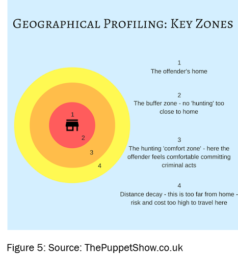
Psychology tells us that serial offenders are creatures of habit. They have a well-defined geographic area of operation. It is their comfort zone and an area of intimate familiarity. They know the lay of the land, they know the people.
Criminal statistics show us that most of these areas of activity are anchored by either the criminal’s home or place of employment. So if we put that location information together into a Geographic profile of the offender then we can use GIS tools to aid Law Enforcement in their criminal investigations.
Geographic Profiling
Geographic profiling is an investigative and information management system that takes the location of incidents and uses that data to determine the likely home base of the offender. Geographic profiling does require multiple data points in order to be effective. And as such it is best suited for use in investigating serial crimes such as murder, rape, arson, burglary, and robbery.
In addition to locating the offender’s likely home base, work, travel routes, and social habits can also be derived by this data. With this geographic information, police can better deploy their resources to investigate the crime. Think of the incident data as arrows on a bullseye only you can’t see the rings. Clusters of incidents tell you where your rings are and the center of your cluster, the Bullseye, tells you the most likely area for the offender’s home base.
Geographic profiling alone will not solve crimes but it is a valuable tool for investigators as they work to apprehend the offender. ESRI© offers a tool in ArcGIS, called Crime Analysis. Criminal Analysis is a GIS tool specifically tailored to take incident data and perform complex spatial analysis and create high-quality maps that can help law enforcement make better decisions on how to allocate resources, investigate and solve cases.
GIS and the Green River Killer
Let’s look at how GIS and geographic profiling were applied to one of America’s most prolific serial killers. He was referred to in the press as the Green River Killer, and between the years 1982 and 1998, the bodies of 48 young women, most of whom were prostitutes, were found in wooded areas along the Green River in Washington State.
In 2001, Gary Ridgway was arrested and ultimately confessed to the murders. To create a geographic profile of Ridgeway, law enforcement begins by taking incident data that was a reasonable match for belonging to the same offender and plots them on a map. By first mapping out the locations that were used to dispose of bodies and information on areas that the victims were most likely to have been taken from (in this case, areas of known prostitution).
When examining the data, investigators are able to see clusters of activity. In Ridgeway’s case, there were two defined clusters, one being the area of victim selection and the other being the area of victim disposal. Data is then analyzed as to what is near these locations. One of the Ridgeway clusters was in an area populated by businesses and the other was in a residential area.
When you analyze that spatial information along with what is known about serial offender psychology, an investigator can make use of that information to better deploy search efforts to locate the offender. This information also can provide insight into commonly traveled routes and other habits. This data is then used to guide law enforcement on how to deploy patrols, area to canvas, and more.
If you are wondering how accurate this information can be, Ridgway’s place of employment was near the cluster representing the last known locations of his victims. According to interviews with Ridgeway, he often looked for victims before and after work.
Ridgway also told investigators that he disposed of his victims near his home because he liked to revisit them. He even went so far as to confirm that because of media coverage and increased police presence in areas that he frequented he had intentionally placed bodies outside of his comfort zone in an effort to throw law enforcement off of his trail.
This is how GIS got into the game of hunting serial killers and other serial offenders. If you are interested in learning more about how GIS can be used by law enforcement to reduce or solve crime check out these great links.
