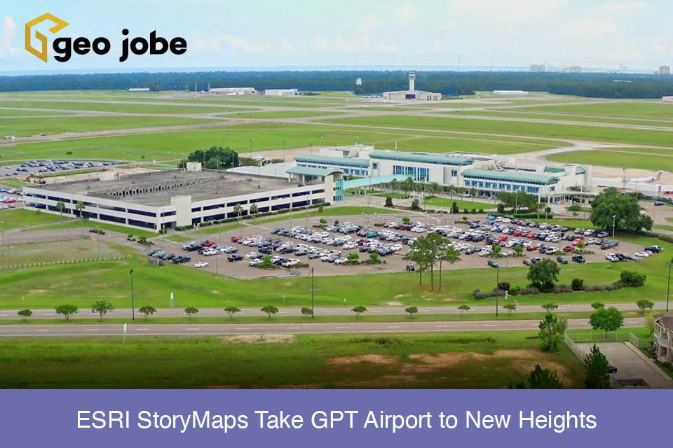
The Gulfport – Biloxi International Airport (GPT) is experiencing growth that depends on the economic development of its parcels for revenue. The existing solution of marketing the available properties was not providing the desired engagement and they knew there must be a better way. When Esri’s partner GEO Jobe introduced them to the power of […]
Tag: story maps
Digital Storytelling With StoryMaps
Stories are powerful; they can advocate for change, influence opinion, and create awareness. ArcGIS StoryMaps are web-based applications that allow you to tell your story by integrating maps, data, pictures, videos, and other media in one place. StoryMaps are my favorite ArcGIS product due to their versatility and ability to augment storytelling through the addition […]
Canines, Cats, & Story Maps
Many people enjoy the perks of having a pet in their life. As geographers, it was only a matter of time before we tried to map them. The GEO Jobe staff has more geopets, as we’ve come to call them, than we initially realized, which made us curious about all the geopets other geographers may […]
ArcGIS ideas – Sharing Code with a Story Map
There’s no question that Story Maps and the Story Map templates are valuable and useful for many things. There are crowd-sourced story maps, some are strictly map based, some share news and event information, others are used to gather crowd-sourced information, and then some stories walk you through a visual experience told through photos and […]
5 Things on Friday #57 – Open Data, ArcGIS Pro, a BIG Data Directory and more!
Once again it’s Friday and time to share some cool, mappy tips, web maps, and web apps. We’ve discovered 5 more awesome resources here that we think you’ll enjoy checking out.
5 Things on Friday #54 – WA State LiDAR, US Army Story Map, US Energy OpenData and more!
Time for our final 5Things on Friday of 2017. This week we share 5 handy geo tips including: A resource with a TON of US energy data, A fun US Army photo journey, the amazing WA State Bare Earth LiDAR resource, and a fabulous training archive to help you with Story Map customization, and more! Do […]
Awesome Story Maps – Geography Helps Understand Where Will Amazon Locate HQ2 and Why?
In College I majored in urban geography. I was totally enthralled with urban planning related matters, architecture, and cities, in particular, how cities grew and the factors that drove people to urban centers. Naturally, as a geographer, it made sense that these things would all, in concert, affect how businesses grew and in particular where […]
San Diego Gaslamp Adventure Story Map App from 2017 ESRIUC Created Entirely with Android Smartphone
While in attendance at the 2017 ESRIUC in San Diego CA, like many of you, we snapped photos, lots of em! Now, photos are great, after all, we can post them to facebook in a Gallery, we can share them in real-time via Twitter and Instagram, however, when you ensure that your photos are location-aware […]
Celebrating Canada’s 150th Birthday with Canadian Themed ArcGIS Online resources
This year, on July 1, Canada will celebrate her 150th birthday (aka. Canada’s sesquicentennial birthday) and what better way to re-live the past and take a historic, educational journey spanning 150 years than with maps, data, infographics, data visualizations, and story maps? Luckily, our own marketing guy (@gletham) hails from the Great White North and […]
5Things on Friday #34 – A 5Things Map Journal of Tips
Welcome once again our 5Things on Friday where we share 5 very cool, handy, mappy related tips suggested by our team members and colleagues. This week we’ve shared a few of our favorites from the past 30+ weeks. Using the Story Map Journal format – we’ve done a bit of a “trial” by sharing our […]