GEO Jobe UAV Services group has been extremely busy this fall flying season, and there’s no sign of slowing down any time soon – although a break over the coming holiday season is going to be very welcomed! Recently, a UAV project conducted by our team was selected as a weekly Monday “3D” spotlight feature by popular UAV solution/software provider, Pix4D.
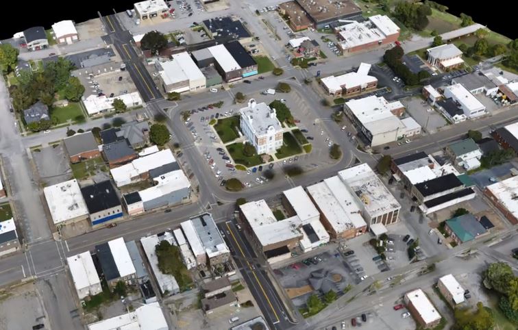
Lewisburg, in Middle Tennessee, where UAV / drone-mapping is helping the city to become a smart-city.
The Project
The Lewisburg water utility is a GEO Jobe GIS Consulting client, contracting GEO Jobe for a number of services, including mapping their utility assets and network. GEO Jobe secured a contract to provide base mapping services and feature extraction for the City of Lewisburg. We used photogrammetry to create orthomosaics to assist the client in capturing and updating GIS features for Emergency 911 address databases, facility management, asset location, and building information models. Additionally, a side product we a created in the form of a 3D model for City marketing and planning uses.
According to Jeff Lawrence, UAV Business Development at GEO Jobe UAV, “GEO Jobe selected Pix4D for its flexibility and the options to edit the models and the project.”
Technical details:
- Device used DJI Phantom 4 Pro
- Image capture path (circular/grid/free terrestrial/aerial) Combined grid and free flight aerial
- Pix4D software used: Pix4Dmapper
- Platform used (desktop or cloud)
- Editing (did you add MTPs, edit the point cloud or added surfaces to the mesh?) We added 5 centimeter-level ground control points.
See the 3Dspotlight at Pix4D Community
GEO Jobe UAV provides high-resolution digital mapping products to public sector clients in local and county governments, as well as private sector clients in the engineering, construction, utilities, and Land Surveying industries. We use drones to deliver standard ortho-aerial updates on sites ranging from 3 acres to almost 600 acres. We also deliver topographic data and models with 1’ contour lines for survey, drainage analysis, and grading compliance.
There are a wide variety of uses and advantages for using a UAV for construction-related projects. Below is a list of some typical applications for UAS that we can provide:
- Earthwork volumetric surveys and 3D modeling
- Topographic mapping
- Infrastructure/deformation monitoring
- Infrastructure inspection
- Asset inventory surveys
- Visualisation surveys
- “Progress mapping” suitable for BIM
- Environmental surveys
- Thermal inspection surveys
The GEO Jobe UAV crew has been busy flying jobs for a variety of clients recently, including UAV and aerial mapping for construction projects and new residential/neighborhood developments, College campus sites and school facilities, utility inspection, mines, a marina, and more. See more information about our UAV services or contact us HERE
Follow GEO Jobe UAV services on Facebook, Twitter & Instagram @geojobeuav
See Also: