Tree Canopy Classification – Vanderbilt University Campus Nashville Quantifying tree canopy cover across expansive areas has historically been a time-consuming endeavor, often reliant on labor-intensive field surveys or manually analyzing traditional aerial imagery. Such methods are not only cumbersome but also prone to error. Through the innovative application of Unmanned Aerial Vehicle (UAV) technology, significant […]
Tag: case study
City of Winter Park Benefits from con terra’s security.manager NEXT
The City of Winter Park is a suburban city in Orange County, Florida and is part of the Orlando-Kissimmee Metropolitan Statistical Area. Winter Park is the city of arts and culture, cherishing its traditional scale and charm while building a healthy and sustainable future for all generations. Like many municipalities, Winter Park faced a challenge […]
Case Study: GEO Jobe UAV and the Sandestin Owners Association
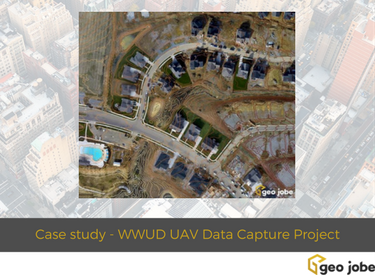
It is not uncommon for organizations to supplement their GIS data with aerial imagery captured from a manned aircraft or drone. This perspective may come as an after-thought to some, being procured after a GIS program has already been established; however, for the Sandestin Owners Association, aerial imagery came before their GIS. Three years ago, […]
AWS and ArcGIS Enterprise, a Case Study on Successful Migration
The Challenge Metropolitan Airports Commission (MAC) was using ArcGIS Online paired with desktop based on-premise workflows. They were looking for a solution that met their security needs while also being self-governed. The solution needed to give the GIS team the ease and ability to administer all parts of the environment.
Case study – Admin Tools for ArcGIS Online Supports Managing Student Accounts at Center of Geographic Science (COGS)
The GIS / Geotech EDU user community, in particular, higher learning, has been very active with Admin Tools for ArcGIS Online since the launch in 2015. In fact, the Geo EDU community is likely our most passionate and appreciative user base.
West Wilson Utility District Turns to GEO Jobe for UAV Data Capture & Orthophoto Updates
In order to remain relevant and a leading service and solution provider in the GIS industry for almost 20 years we constantly have a need to adopt new technologies, push the limits, and add complementary tech and services to our offerings. GEO Jobe has been integrating UAV / UAS data capture into a number of […]
Case Study – Esri Partners Working With Partners: Bringing Mapillary to the ArcGIS Marketplace
Here at GEO Jobe we not only use ArcGIS for project work and custom services for clients, we also build on the ArcGIS platform (think Admin Tools and GEOPowered Cloud). In order to build apps and make them widely available via the ArcGIS Marketplace we’ve been a long time Esri Business partner. An added benefit […]