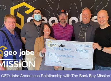
GEO Jobe CEO David Hansen (far right) and COO Daniel Menikheim (far left) present a check to MISSISSIPPI Heroes Executive Director Katherine Sutton (center right) and Board President Eric Alvarez (center left). GEO Jobe is proud to announce a new partnership with a local nonprofit to build wheelchair ramps for residents throughout Mississippi. GEO Jobe […]
Tag: community
GEO Jobe Announces Relationship with The Back Bay Mission
GEO Jobe is pleased to announce a donation to The Back Bay Mission. This donation of $10,000 on behalf of GEO Jobe symbolizes their investment into the Mississippi Gulf Coast to help impoverished individuals get the food, housing, and education they need to help transform their lives. GEO Jobe’s financial contributions strengthen the community by […]
Building Your Community Engagement Strategy With ArcGIS
In a time when cities, governments, non-profits, and even private businesses are looking to connect with their communities, we need to ensure that our methods for engagement are intentional and authentic. With technology becoming a part of our everyday lives, it is easy to send out a quickly drafted survey, write a report on the […]
Community Engagement With ArcGIS Hub
Looking for new community engagement methods? Want to make data available for your community? ArcGIS Hub is a cloud based platform that makes working directly with your community more effective and streamlined; it is a way to get GIS tools into the hands of community members. From open data sites to community initiatives, ArcGIS Hub […]
GEO Jobe UAV Services Recognized by Pix4D – Lewisburg, Tennessee Drone-Mapping for Smart Cities
GEO Jobe UAV Services group has been extremely busy this fall flying season, and there’s no sign of slowing down any time soon – although a break over the coming holiday season is going to be very welcomed! Recently, a UAV project conducted by our team was selected as a weekly Monday “3D” spotlight feature […]
GEO Jobe Connecting With GIS Professionals, Admin Tools Users, and the ArcGIS Online Community
We realize here at Geo Jobe that supporting our customers, users, and the ArcGIS Online user community at large is a great responsibility and something we take quite seriously and are proud of. We’ve developed a number of useful resources to connect with and support our community. We share some of these below and hope […]


