Take advantage of one of Esri’s best marketing tools, ArcGIS StoryMaps. Whether you are advertising your products, selling property, advocating for a cause, or even wanting to provide your company’s background, StoryMaps has it all. Working in an Enterprise environment? No worries, ArcGIS StoryMaps is available to you, too! Telling Your Story For this article, […]
Tag: map
Enhancing Field Workflows with ArcGIS Field Maps using Related Tables
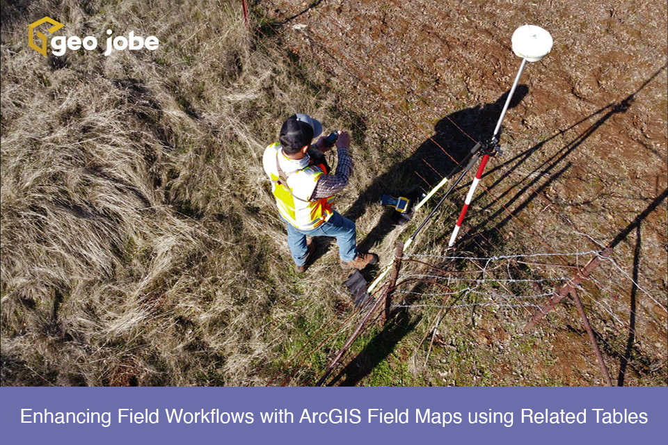
ArcGIS Field Maps is a powerful application within the Esri ecosystem that helps streamline workflows for data capture and asset monitoring out in the field. Multiple use cases for field maps have been utilized, from mapping sightings of invasive species to tracking damage to homes after storms. One of the most common use cases is […]
Understanding Circular Dependencies and How to Fix Them
A dependency is when an item needs another item to function properly. For example, if your web map has a layer, that layer is a dependency for the web map. Circular Dependencies are when items appear to link back to themselves. They may do so directly, or through a chain of connected items. Either way, […]
City of Winter Park Benefits from con terra’s security.manager NEXT
The City of Winter Park is a suburban city in Orange County, Florida and is part of the Orlando-Kissimmee Metropolitan Statistical Area. Winter Park is the city of arts and culture, cherishing its traditional scale and charm while building a healthy and sustainable future for all generations. Like many municipalities, Winter Park faced a challenge […]
Creating Custom ArcGIS Map Widgets as React Components
Map Widgets The ArcGIS Maps SDK provides many useful widgets to extend an ArcGIS map for the user. However, sometimes the requirements of a GIS application are so specific that custom functionality must be created to meet those needs and another Map widget is often the perfect place to place these new features. Especially if […]
How to Reconfigure Layer Files in ArcGIS Pro
Symbology is one of those things that can make or break a map. If it is not clear and intuitive, users can be left feeling frustrated by the lack of clarity and the amount of time it takes to find what they are looking for. (I can’t be the only person who walks away grumbling […]
Celebrating St. Patrick’s Day Around the World
St. Patrick’s Day is celebrated annually on March 17th all around the world and honors Ireland’s patron saint, St. Patrick. Grab your favorite green outfit and join me as we take a walk around the world and explore how an unassuming Irish holiday has spread around the world and become an international occasion. Bright Green […]
Around the World in Just One Night
The holiday season and Christmas are once again almost upon us. Christmastime can be busy, and filled with an abundance of things; work that needs to be finished by year end, holiday shopping or taking time off for that perfect winter vacation. As you are out and about you will find many businesses are filled […]
Get to Know Your Toolbox – Tools Used to Cache Imagery in ArcGIS Pro and Publish to ArcGIS Online!
Do you have imagery you would like to upload to ArcGIS Online for a basemap? Well, this article is going to take you through the steps to get you there. Come with me as we create you a custom basemap! Prepping your Imagery The first step in caching imagery is to create a mosaic dataset […]
Get to Know Your Toolbox – Map Series in ArcGIS Pro
The Map Series, in my opinion, is one of the most underrated tools in ArcGIS Pro. It is a fantastic way to customize reports that summarize data within a polygon layer. The ability to use queries and dynamic text that provide answers to the questions being asked for multiple areas of interest is a breeze. […]